Friday, 9 February 2018

9 February – Memphis


Cleaning day! Took the RV in for a major Jiffylube, so she is all mechanically ready for Mick and Matilda in May. Then off to the truck wash for the wash and shine, refuel, and top up of the propane (LPG).


Then back to the RV park for cleaning, laundry and getting ready to pack.

8 February – Decatur to Memphis


Last day of travel. We took one of the back highways along the Mississippi / Tennessee border back to Memphis. Lovely countryside, old barns, fallow cotton fields and rolling woodland hills.


Sad to be finishing another wonderful holiday, and bracing ourselves for the big pack up tomorrow.

Wednesday, 7 February 2018

7 February – Gadsden to Decatur


We headed out in the morning and as we had a lot of rain overnight we thought we’d check out the falls again. Lots more water going over today!

We drove the back ways and by ways to Cathedral Caverns. Cathedral Cavern has reputedly the widest entrance to a commercial cave, at 126 feet wide and 25 feet high. 


The cave tour is 1.5 miles in total, but the cave itself is much longer and mostly not open to the public. There has been documented habitation of the cave for thousands of years, but it was explored and opened as an attraction in the 1950s. Definitely worth a visit, and the tour guide was fun. He was a self-confessed hillbilly with a southern accent that we could barely understand, and a real passion for the caves.


Click the link below to see where I am located.
http://fms.ws/sV8Xd/34.62347N/87.00836W

If the above link does not work, try this link:
http://maps.google.com/maps?f=q&hl=en&geocode=&q=34.62347,-87.00836&ll=34.62347,-87.00836&ie=UTF8&z=12&om=1 

6 February – Gadsden


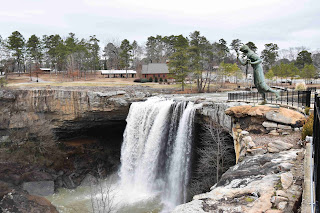
We had intended to drive north to a cave, but on googling it found it was closed. The campsite was lovely so we opted to stay a night longer and visit Noccalula Falls instead. Quite impressive and lots of geese around. There is a statue overlooking the falls of Noccalula jumping off, which is a tad morbid. And she has ginormous feet!


We had a quiet day of laundry and books.

5 February – Mobile to Gadsden


We got a couple of stone chips in the windscreen fixed, by a New Zealander lady who had spent time in WA as a FIFO worker. She gave us a great discount on account of us being her Aussie mates. Then a day drive north to Gadsden. 

We found an RV park in a lovely place at Noccalula Falls. The falls are named for a young daughter of a chief, who promised her in marriage to a warrior of another clan to ensure peace between them. Noccalula was in love with someone else, and at her wedding feast she slipped away and jumped to her death over the falls.


Pretty place, very peaceful and lots of native critters around.


Sunday, 4 February 2018

4 February – Mobile

We spent the day at USS Alabama Battleship Memorial Park. The park is dedicated to Alabama Veterans, and has on display the USS Alabama, the submarine USS Drum, and lots of aircraft. We started on the Alabama.


The first self-guided tour took us all round the above decks and superstructure, including looking into the gun turrets, on the bridge and the battle bridge – 16 inch thick armour plating. We climbed up to level 8 above deck, with probably another 3 levels above that. The first thing you notice on the tour is the ships guns. Her main guns are nine 16 inch / 45 calibre and accurate to 21 miles. The shells were nearly as tall as a person. She also has twenty 5 inch / 38 cal guns, forty-eight 40mm guns and fifty two 20mm guns. That’s a lot of guns… It took a crew of 2500 to manage all of that.


Following the above decks tour we did the stern section below decks tour – a fascinating look into life aboard a WW2 battleship. We saw the accommodation (pretty packed in), mess halls, the brig, laundry, butchers, bakers, (no candlestick makers). There was even a tribute to the HMAS Perth and some info on the Australian naval input into the War in the Pacific.


The Alabama was nicknamed the Lucky A as she survived the war unscathed, and in fact the only casualties were 5 men killed when one of the Alabama’s guns accidentally fired into one of her own gun turrets.


We then toured the aircraft pavilion then onto the USS Drum. The tour takes you down via the forward torpedo room, through the sub, then out via the after torpedo room. It was interesting, and a little claustrophobic at times! The Drum is the oldest US sub on display.


Fun fact: The Alabama was used as a set for the movie “Under Siege”.


Back at the RV park, and apparently the super bowl is on. We aren’t watching, but we can hear it all play by play. 

Saturday, 3 February 2018

3 February - Mobile

We headed out to Dauphin Island and to take a look at Fort Gaines. Dauphin Island was mapped as early as 1519 by the French and in 1707 was the capital of the French Louisiana territory, which covered almost two thirds of the United States.

Mobile Harbour is entered by a narrow stretch of water and during the civil war Fort Gaines and its twin, Fort Morgan on the other side of the entrance, were protecting the harbour from the Union. By 1864 Mobile Harbour was one of the last ports open to blockade runners bringing in supplies to the confederate army, and the battle for the harbour was epic. The confederate army had a single ironclad, the Tennessee, and despite mining in the harbour and the bombardment from the two forts, the Union fleet broke through and the Tennessee was forced to surrender. After 2 days of heavy bombardment, and with their guns destroyed by Union fire, the fort also surrendered.


The self-guided tour was really interesting and took us several hours. There was a working blacksmiths shop where a blacksmith was demonstrating his work. The fort had over 60 guns and 400 men during the war and is in reasonable repair, given how much it was battered, so there was lots to see. They even had “flushing” toilets – there was a channel dug under the latrines that washed out with the tide coming in and out.


Following the fort visit we went to the Islander restaurant for lunch. More Cajun style seafood – so yum!

Back to the RV park via a fish market to buy fresh fish for dinner.

Click the link below to see where I am located.
http://fms.ws/sMyAo/30.36797N/88.11356W

If the above link does not work, try this link:
http://maps.google.com/maps?f=q&hl=en&geocode=&q=30.36797,-88.11356&ll=30.36797,-88.11356&ie=UTF8&z=12&om=1 

2 February – Foley to Mobile

Ros had picked up a dose of the flu, so we decided to take it easy today and drive on to Mobile. We found an RV park on the Dauphin Island Parkway and settled in for the afternoon of relaxing.

Click the link below to see where I am located.
http://fms.ws/sKqDv/30.36796N/88.11359W

If the above link does not work, try this link:
http://maps.google.com/maps?f=q&hl=en&geocode=&q=30.36796,-88.11359&ll=30.36796,-88.11359&ie=UTF8&z=12&om=1 

1 February – Miramar Beach to Foley

We idled along the beach highway with stops for sushi lunch and to look at the sea. We saw the Naval Airforce base at Pensacola, they have their own hospital and shopping mall. The Blue Angels are squadroned there but they weren’t flying.

We crossed the border into Alabama, and waved goodbye to Florida.


Getting into Foley we looked for an RV park. The first one wouldn’t let us in because we weren’t driving an A class (how snobby!), and the second one was full. Third time lucky!


Wednesday, 31 January 2018

31 January – Eastpoint to Miramar Beach

We had a leisurely drive along the coast, with a stop at Seaside – the town used as the set for the Jim Carrey movie “The Truman Show”. Really nice little place, but they value privacy and most of the streets and beach accesses are for residents only.


We stopped at Panama City beach as well, for a leg stretch, then on to Camp Gulf. Right on the beach but the most expensive RV park we’ve stayed at - $99 per night. Usual prices $30 - $40 per night. But the beach is amazing, white sand that looks like snow on the beach, blue and turquoise water, and pelicans.


What a wonderful bird is the pelican
His beak can hold more than his belly-can
He can hold in his beak
Enough food for a week
And I’m damned if I know how the hell-he-can

(paraphrased – apologies to the author)


30 January – Eastpoint

We decided to kick around the area today and started with a visit to St George Island. The island is a barrier island and reached by a very impressive bridge. We pulled in first at the lighthouse, which was located on Little St George Island, but fell down in 2005 and was recovered and rebuilt in the current location. Nice view from the top and an interesting museum in the lighthouse keepers cottage.


We drove from one end of the island to the other for the views, lots to see. Lunch at The Blue Parrot was lovely, lots of seafood and very friendly staff. We had a mixed seafood platter and snow crab.


After lunch we walked on the beach, then headed off the island and to the town of Apalachicola (no, we can’t pronounce it!). We browsed the arty shops and sampled chocolates at the local chocolatier. All very quaint. 

29 January – Perry to Eastpoint

We headed West from Perry, towards the Gulf Coast. Miles of very straight roads through swamp forests. We detoured into a small place called St Marks for lunch at a riverside café - seafood was tasty. Steve had the gumbo, rice, chilli, seafood and sausage. Not much to St Marks, so we pushed on.

Finally on the coast and it was breathtaking. The road follows the coast line closely, through tiny communities of houses on stilts, often right on the water with jetties. We were enjoying the view and decided to pull in at an RV campsite right on the water. We got a front row spot, within a stone’s throw of the water. Even though it was early, we called it a day. They have WiFi, which is a bit of a treat, so we can catch up on emails.


Click the link below to see where I am located.
http://fms.ws/sBP5G/29.75387N/84.84229W

If the above link does not work, try this link:
http://maps.google.com/maps?f=q&hl=en&geocode=&q=29.75387,-84.84229&ll=29.75387,-84.84229&ie=UTF8&z=12&om=1

Monday, 29 January 2018

28 January – Crystal River to Perry

In the morning we headed into the township of Crystal River and caught the trolley bus to Three Sisters Spring, where manatees gather and you can see them from the shore. Like the springs we saw in the Ocala Forest, the many springs on the coast come out of the ground at around 72 degrees F (23C) and provide the manatees with a heat source during the winter. When the water is too cold for them, they swim upriver to the springs and loll about like cows chewing cud, in the warm water.
The Three Sisters Spring is shaped like a 3 leaf clover, with a spring boil in each lobe. There were around 50 manatees in the springs this morning, although we were told that on Monday it was cold and there were 350 of them.


The water is clear and turquoise blue, due to the concentration of tiny particles reflecting light. The manatees are big and somnolent, occasionally breaking the water with their noses to take a breath.  In the right light they almost look like big river boulders, tumbled into oval shapes by the water, as they cluster over the spring boils, basking. Odd to think that ancient mariners thought they were beautiful women with fish tails and the legends of mermaids began. If you squint, and remember that sailors often didn’t see women for months on end, maybe and after a flagon o rum, just maybe you can see it…


On the drive north we stopped in at Cedar Key, a delightful little town. Unfortunately it started to rain, so we decided to drive on. Buckets of rain made the highway driving unpleasant and we were glad to find a truck stop with a small RV parking lot for the night.

Click the link below to see where I am located.
http://fms.ws/s7tGN/28.89958N/82.625W

If the above link does not work, try this link:
http://maps.google.com/maps?f=q&hl=en&geocode=&q=28.89958,-82.625&ll=28.89958,-82.625&ie=UTF8&z=12&om=1 

27 January – Juniper Springs to Crystal River

In the morning we hiked to Juniper Springs. It’s a pretty place, with a historic waterwheel and mill house that was used to generate electricity in the 1930s. The spring boil was deep and from the right angle we could see it is a small underwater cave.


We saw kayakers heading off downstream, but one of them was having trouble staying upright. The water was less than knee deep, so he wasn’t getting all that wet though.

We also walked a section of the Florida trail, through the forest, before packing up and heading out.
We had an uneventful drive South and across to the West coast of Florida to Crystal River. It took two tries to find a campsite as there is a Bluegrass festival in town for the weekend. Crystal River is where the main population of manatees hangs out in winter, the spring water is warmer than the rivers and lakes, so they head in for the warmth.

Click the link below to see where I am located.
http://fms.ws/s7tGN/28.89958N/82.625W

If the above link does not work, try this link:
http://maps.google.com/maps?f=q&hl=en&geocode=&q=28.89958,-82.625&ll=28.89958,-82.625&ie=UTF8&z=12&om=1 

26 January – Alexander Springs to Juniper Springs

In the morning we hired a canoe for a couple of hours and explored the river. The canoe hire is pretty laid back, they give you a canoe, paddles and life jackets and point you in the direction of the boat ramp.

We managed to launch without getting wet, and headed downstream at a leisurely pace. The wind and the current were going the same way, so it just took a bit of steering and gentle paddling to keep us underway. As we left the spring basin the river was shallow and sandy bottomed, with water lilies lining the banks.


We saw lots of wildlife – diving birds that bob their heads up for air, herons wading in the lilies, turtles sunning on the logs, and a big alligator. It was around 5 feet long, big bellied, grey, and lying on a log with its feet dangling lazily. We paddled as close as we felt safe to get pics and admire from a distance. It ignored us completely. The locals had told us that alligators are mainly scared of people and will run away, not like big salty crocs that hunt you down for dinner. Just as well, cos we imagine that the alligator could swim a lot faster that we could possibly paddle.


The canoe was pretty easy to handle and we made good speed to the bridge, where we had been told to turn around. The lilies were budding, big yellow buds, they would probably be spectacular in flower. It was beautifully peaceful, just the splash of the paddles and the ripples of the canoe cutting across the water, with bird sounds and the breeze.


The return trip was harder work as we were paddling against the current. Mr Gator was still at ease on his log, with his mouth open this time in a big grin. We kept to the other bank.


We passed several other canoes and kayaks heading downstream, seems like a popular place.
When we got back the canoe hire people were surprised that we weren’t wet. It’s supposed to be very easy to tip a canoe over.


We decamped and headed up the road to Juniper Springs. We decided to take an easy afternoon, reading and resting in the warm weather.